
S-100 Products and Services
The universal hydrographic data model S-100 is a set of guidelines and definitions for the design and updating of hydrographic geospatial products and services.
It is the new international standard developed by the International Hydrographic Organization (IHO) to ensure uniformity of maritime products and services.

Table of Contents
- S-101 Electronic Navigational Chart (ENC)
- S-102 Bathymetric Surface
- S-104 Water Level Information for Surface Navigation
- S-111 Surface Currents
- S-122 Marine Protected Areas (MPAs)
- S-123 Maritime Radio Services
- S-124 Navigational Warnings
- S-125 Marine AtoN
- S-127 Maritime Traffic Management
- S-128 Nautical Product Catalogue
- S-129 Under Keel Clearance Management (UKCM)
- S-131 Marine Harbour Infrastructure
- S-201 Aids to Navigation Information
- S-411 – Sea Ice Information
- S-412 – Weather Overlay
- S-413 Weather and Wave Conditions
- S-414 Weather and Wave Observations
- S-421 Route Plan
S-100 supports the integration of various digital nautical data, including, but not limited to:
Environmental Information
Meteorological information
Marine weather forecasts and conditions, including buoys & stations data.
Surface currents
Predicted times and heights of high and low waters, and the hourly water levels for over seven hundred stations in Canada.
Water Levels
Water level forecasts and observations, including tide and current tables.
Hydrographic and Geospatial Information
CHS Digital Data Portal
Electronic Navigational Charts (ENC)
High-resolution bathymetry
Waterway information, layers accessible with our interactive map.
Navigational Safety Information
Aids to navigation
Status of buoy tending operations.
Navigational warnings
Current navigational warnings (NAVWARNs), including notices to shipping, notices to mariners (NOTMAR), shoals and status of aids to navigation.
Hydrographic and Geospatial Information
Port and Operational Information
Remote, local and public port facilities. Canada Port Authorities (CPA)
S-101 Electronic Navigational Chart (ENC)
The Electronic Navigational Chart (ENC) is a digital vector product providing a real-world depiction of navigationally essential information needed to best ensure safe navigation. It forms the base upon which many other S-100 data products can be overlaid.
The ENC meets the requirements of the International Maritime Organization (IMO) and the SOLAS Convention (Safety of Life at Sea) for use in electronic navigational systems such as Electronic Chart Display and Information Systems (ECDIS) and Portable Pilot Units (PPUs).
The S-101 standard aims to replace products based on the older IHO S-57 standard. During the transition period, S-57 products will continue to be distributed alongside S-101 ENCs. As with S-57 ENCs, S-101 ENCs will be distributed through a Regional ENC Coordinating Center (RENC) in accordance with international practices.
In Canada, the Canadian Hydrographic Service (CHS) is progressively producing and distributing new S‑101 charts to support the global transition to the standard within the International Hydrographic Organization (IHO), while working closely with industry and government partners to promote the adoption of S‑100‑compatible ECDIS.
Access to S-101 Product: CHS Digital Data Portal / Service portail de données numériques du SHC
For more information, please consult the following:
-CHS - S-101 Electronic Navigational Chart (ENC) Video
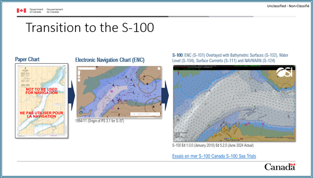
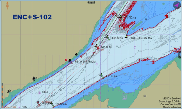
S-102 Bathymetric Surface
The S-102 bathymetric surface product is a digital elevation model representing the seabed or the bottom of other water bodies in a regular grid format. It is designed to support safe and efficient navigation by providing high-resolution bathymetric data.
When used in conjunction with other S-100 products, the bathymetric surface facilitates operational decision-making for navigators. In addition to depth values, the product may include data on the uncertainty associated with these measurements.
In Canada, the Canadian Hydrographic Service (CHS) produces three different resolutions of S-102 bathymetric products to meet the varied needs of users.
Additionally, CHS offers Non-Navigational Bathymetric Data (NONNA), a bathymetric surface product available free of charge for non-navigational use.
For more information, please consult the following:
•CHS
- S-102 video
•CSEM | MSRC - S-102
Bathymetric Surface video (French only)
•CHS
- Seabed Mapping: A Navigational Breakthrough?
•Electronic
Chart Centre - How S-102 Bathymetric Data is
Produced
https://blog.ecc.no/how-s-102-bathymetric-data-is-produced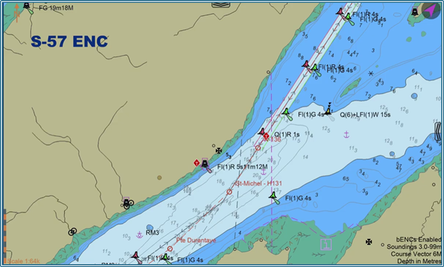
S-104 Water Level Information for Surface Navigation
The S-104 product provides essential water level information to support safe surface navigation. Its data sources include:
•real-time observations,
•predictions (based on tidal constituents in tidal
waters and recorded climatology in inland waters),
•short-term forecasts generated by hydrodynamic
models driven by environmental conditions,
•hybrid solutions such as observation-corrected
predictions or model outputs.
Under the initial S-100 “Route Planning” implementation, the S-104 product format has been limited to regularly gridded datasets that include both water level and water level trend (rising, falling or stable). These grids may also include optional uncertainty information, provided either as a global value or as a gridded uncertainty field. This restriction has facilitated the development of interoperability within ECDIS and PPU systems between S-102 (Bathymetric Surface Products), S-101 (ENC) and S-104 datasets. Together, these products support the calculation and display of dynamically evolving depths, thereby improving navigational accuracy and safety. Future S-104 versions may expand to include irregular grid formats and fixed location (station wise) data options.
The S-104 products are fundamentally grid-based and incorporate a dynamic component. Depending on the use case, they may include near real-time water levels or forecasts values derived from hydrodynamic modelling. S-104 datasets may be provided for fixed stations, a regular grid, or an irregular grid.
S-104 can be used to refine depth information displayed in S-101 (ENC) and S-102 (Bathymetric Surface) products, resulting in improved navigation accuracy and enhanced safety.
In Canada, S-104 is produced by the Canadian Hydrographic Service (CHS)
For more information, please consult the following:
•CHS - S-104 Water Level Video
•Admiralty - S-104 and S-111: Tidal services supporting safer, smarter navigation
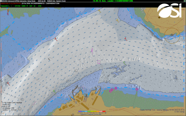
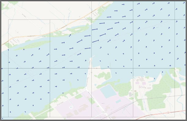
S-111 Surface Currents
The S-111 Surface Currents product provides information on the movement of surface waters from several sources:
•Real-Time observations;
•Predictions;
•Short-term forecasts generated by hydrodynamic models
driven by environmental conditions;
•Hybrid solutions; etc.
In the same manner as for S-104.
The data are presented as time series indicating current speed and direction. These may be provided:
•at a defined depth levels or at multiple
depths;
•as depth-averaged values over specified depth
ranges;
•Regular grids (DCF2);
•Irregular grids (DCF3);
•Station-wise datasets (DCF8).
The associated metadata describe in detail the type of product provided.
Early versions of the product will focus primarily on currents representative of conditions within the top 5 meters of the water column, or at specific depths when representing real-time- observations, predictions, or model outputs intended for comparison with observations.
S-111 products are designed to be overlaid with S-101 (ENC) to enhance the information available for safe navigation. Various coverages and spatial resolutions are provided to meet diverse operational needs.
For more information, please consult the following:
•Tracking
Ocean Currents for Safer Navigation
•CHS - S-111 Surface Currents
S-122 Marine Protected Areas (MPAs)
The S-122 product encodes information related to Marine Protected Areas (MPAs) so that they can be standardized when digitally represented through Electronic Chart Display and Information Systems (ECDIS) and other information systems. It provides a consistent structure for describing MPA boundaries, restrictions, and regulatory information to support safer navigation, better environmental protection measures, and improved decision‑making.
MPAs are designated conservation zones located in marine environments such as oceans, coastal waters, estuaries, and the Great Lakes. The information describing these areas is complementary data within the S‑100 framework and is used to enrich S‑101 Electronic Navigational Chart (ENC) products. The integration of MPA boundaries in S‑101 charts provides mariners with a clearer understanding of environmentally sensitive or restricted zones, supporting informed decision‑making and contributing to safer navigation.
For more information, please consult the following:
•IHO
Nautical Information Processing Working Group - S-122 Marine
Protected Areas
•IHO
GI Registry - Document Register - S-122 Marine Protected
Areas (MPAs)
•Canada's
marine protected and conserved areas
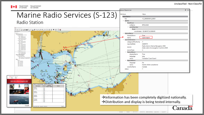
S-123 Maritime Radio Services Services
The S-123 product provides information on maritime radio services, including their location, availability, communication types, frequencies, and the content of services used for navigation and other maritime communications as found in the Radio Aids to Marine Navigation (RAMN) publication.
This information is considered complementary to S‑101 Electronic Navigational Charts and enhances situational awareness, contributing to improved safety and operational efficiency at sea.
For more information, please consult the following:
•NIPWG
- S-123 Marine Radio Services
•IHO
- S-123 Marine Radio Services Product
Specification
•IHO,
bureau véritas, OffShore - Connectivity coverage for remote
operations
•RAMN - Canada.ca
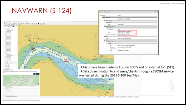
S-124 Navigational Warnings
The S-124 product is designed to create standardized datasets containing navigational warning information, primarily for use within Electronic Chart Display and Information Systems (ECDIS).
A navigational warning is an urgent maritime safety message transmitted to ships in accordance with the requirements of the International Convention for the Safety of Life at Sea (SOLAS). These warnings are critical essential to safe navigation and must be disseminated rapidly.
Traditionally, navigational warnings were transmitted only by radio in voice or text formats. With the introduction of S‑124, digital navigational warning services will become a central component of future Maritime Safety Information (MSI) distribution, providing a modern alternative to conventional communication methods. S‑124 will enable the direct display of maritime safety information within ECDIS, improving timeliness, accuracy, and situational awareness.
The Canadian Coast Guard (CCG) provides an S-124 data service that distributes Navigational Warnings (NAVWARNs) issued by CCG in accordance with the S-124 standard and compliant with the Secure Communication between Ship and Shore (SECOM) framework.
Unlike traditional services that rely on downloadable charts or files, the CCG S-124 service uses a web-based interface designed for direct system-to-system data exchange.
⚠ Test Phase: This service is currently under development and is offered to the public for testing purposes only. It may be updated or modifiedwithout notice.
Please also note that CCG S-124 (Navigational Warning) data are not distributed via the PRIMAR service.
For more information, please consult the following:
•CHS - S-124 Navigational Warnings
•S-124 Service – User Guide
•Sample S-124 datasets for the Canadian S-100 testbed
area are currently updated regularly and available [here].
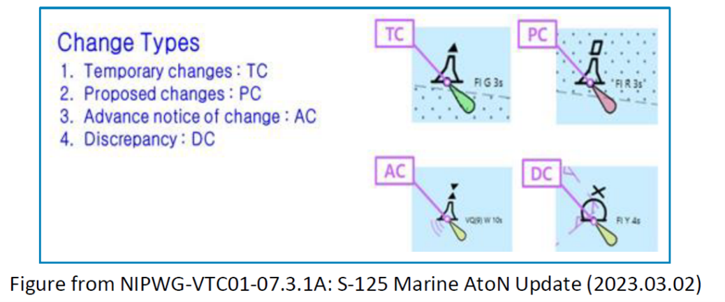
S-125 Marine AtoN
The S-125 Marine Aids to Navigation (AtoN) product is designed to serve as the link between S-124 Navigational Warnings and S-101 Electronic Navigational Charts in situations involving changes to an AtoN’s status.
AtoN discrepancies (DC) and temporary changes (TC) received through S-124 Navigational Warnings may be converted into S-125 until the issue is resolved or the AtoN returns to its standard configuration. Proposed changes (PC) and advance notice of changes (AC) to AtoN originate in S-125 and remain there until the change becomes permanent and is incorporated into S‑101.
This information is considered complementary to S‑101 Electronic Navigational Charts and supports improved situational awareness, safety, and operational efficiency at sea.
For more information, please consult the following:
•NIPWG Product Specifications - S-125 Marine Aids to Navigation (AtoN)
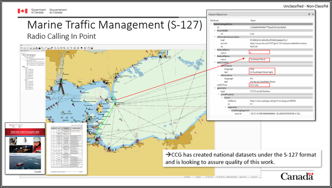
S-127 Maritime Traffic Management
The S-127 product provides information on maritime traffic management, including vessel traffic services (VTS), pilotage, traffic organization systems, and ship reporting systems. These data describe service availability, reliability, areas of coverage, the types of services offered, and instructions for contacting or making use of these services.
S-127 is designed as a complement to S-101 Electronic Navigational Charts. It does not depict geographic information at ENC detail but instead uses simplified geometry to indicate location and provide access to associated regulatory or operational information.
In Canada, S-127 is produced by Canadian Coast Guard’s Marine Communications and Traffic Services (MCTS) program.
For more information, please consult the following:
•IHO - Geospatial Information Registry - S-127 Marine Traffic Management
S-128 Nautical Product Catalogue
The S-128 product provides a digital catalogue of available nautical products, including navigation charts, publications, and S-100-based products, as well as online e-Nav services. Its purpose is to simplify the discovery and acquisition of nautical products and services.
The catalogue contains information such as coverage area, publication date, update status, and producer. Compliant with the S-128 standard, this vector catalogue can also be displayed in ECDIS systems.
It includes access metadata for all S-100 products and services distributed by the Government of Canada.
In Canada, S-128 is produced by Canadian Hydrographic Service (CHS).
For more information, please consult the following:
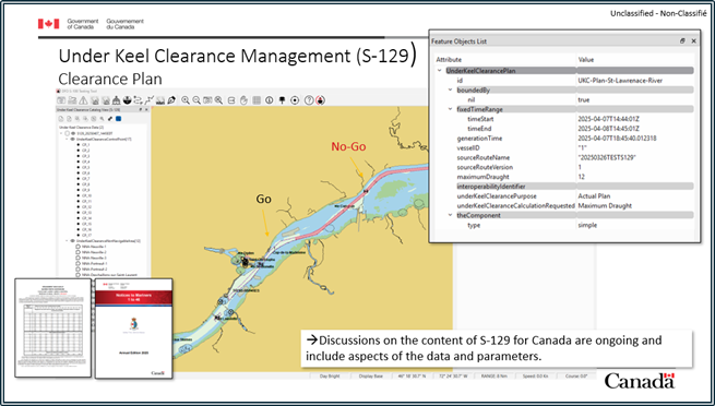
S-129 Under Keel Clearance Management (UKCM)
The S-129 product is designed to provide a standardized format for exchanging digital data related to under keel clearance management (UKCM), to improve maritime safety and traffic efficiency in shallow areas.
It contains the necessary attributes to enable information exchange between a UKCM management system and a navigation system such as an ECDIS.
S-129 is used in conjunction with S-101 (ENC), S-102 (Bathymetric Surface), and, where applicable, S-421 (Route Plan). It allows UKCM services and participating vessels to exchange critical information to ensure safe navigation in areas where these services are available.
In Canada, S-129 is produced by Canadian Coast Guard, waterways program.
For more information, please consult the following:
•IHO - S-129 Test Proves Situational Achievements In Maritime Operation
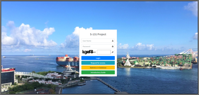
S-131 Marine Harbour Infrastructure
The S-131 product provides detailed information on marine harbour infrastructure to improve situational awareness before approaching a port. It supports planning movements from one berth to another and offers the ability to integrate additional contextual information, such as local water depth, complementing data available in S-101 (Electronic Navigational Chart) and S-102 (Bathymetric Surface) products.
For more information, please consult the following:
•The
S-131 data model and potential for encoding
•IHO
- S-131 Marine Harbour Infrastructure
•NIPWG9
- S-131 Update
•S-131
Marine Harbour Infrastructure
•GitHub - IHO-Lab/S131DB
•NIPWG - S-131 Harbour Infrastructure
S-201 Aids to Navigation Information
The IALA S-201 Product Specification provides a standardized digital structure for the exchange of information on Aids to Navigation (AtoN). In the Canadian context, S-201 supports the operational needs of the Canadian Coast Guard (CCG), the Canadian Hydrographic Service (CHS), and other Canadian marine stakeholders involved in the provision, management, and maintenance of AtoN.
S-201 applies to all categories of marine aids used in Canada, including buoys, beacons, lights, radar transponders, audible signals, lighthouses, and AIS AtoNs. The specification enables federal authorities, regional operations centers, and external partners to share consistent, high-quality AtoN data across national and regional systems, supporting safe and efficient maritime navigation in Canadian waters, including Arctic and remote regions.
Developed under the IALA S-200 framework and built on the IHO S-100 Universal Hydrographic Data Model, S-201 provides a harmonized structure for representing the position, characteristics, operational status, and maintenance or engineering details of aids to navigation. The model also supports metadata relevant to Canadian AtoN operations, such as power sources, moorings, fixing methods, ice conditions, and equipment types, allowing for comprehensive lifecycle and asset management.
S-201 datasets enable the Canadian Coast Guard and its partners to exchange AtoN information seamlessly, supporting:
•Operational monitoring and situational
awareness
•Planning and prioritization of AtoN maintenance
•Reporting and asset lifecycle tracking
•Interoperability between national and international
maritime navigation systems
While S-201 complements CHS navigational products such as S-101 Electronic Navigational Charts, it is not intended for ECDIS use. Instead, it provides detailed operational and technical information essential to the Canadian Coast Guard’s role as the responsible authority for the provision and maintenance of marine aids to navigation in Canada.
For more information, please consult the following:
•IALA - S-201 AtoN Information
•IHO - Geospatial Information Registry S-201
S-411 – Sea Ice Information
The S-411 product provides vector-based information on the extent and nature of sea ice for navigation purposes. Data is encoded using Geography Markup Language (GML) in accordance with the S-100 standard.
This product offers visual portrayals and dynamic messages to the maritime community to report local ice analyses and forecasts within operational areas, in compliance with the World Meteorological Organization (WMO) standards (No. 558/471/574), IMO Resolutions, and the SOLAS Convention. The information includes:
•Ranges of ice concentration
•The extent of sea and lake ice
•The general location and concentration of
icebergs
•Stages of ice development
These details are considered supplementary data that enhance S-101 (Electronic Navigational Chart) products, supporting safe navigation in polar and ice-covered regions.
For more information, please consult the following:
S-412 – Weather Overlay
The S-412 product provides marine weather warnings in the form of polygons that depict areas where hazardous conditions are occurring or forecasted, in accordance with criteria established by WMO (Pub. No. 558/471), IMO Resolutions, and the SOLAS Convention. These warnings may include wind, wave, ice accretion, and other coastal or offshore phenomena such as near gale-force winds, thunderstorms, squalls, and reduced visibility.
Polygon-based warnings allow mariners to anticipate adverse weather conditions along their route. This product is designed to reproduce and enhance the traditional radiofax charts currently used by mariners, offering a modern digital presentation integrated into ECDIS systems.
The S-413 specification complies with WMO standards, including:
•Manual
on Marine Meteorological Services, Volume I – Global Aspects
(WMO No. 558)
•Guide
to Marine Meteorological Services (WMO No. 471)
For more information, please consult the following:
S-413 Weather and Wave Conditions
The S-413 product provides meteorological and oceanographic analysis and forecasts in both graphical and gridded formats to support maritime safety and route efficiency. It includes data on wind, waves, visibility, and other parameters, delivered in Hierarchical Data Format 5 (HDF5) for gridded datasets. The gridded weather data available in S-413 provides polygons and gridded information of winds, waves, visibility, etc. Graphical portrayals illustrate the positions of weather systems over the oceans, including frontal systems, cyclonic low-pressure systems, and regions of high barometric pressure. This product extends beyond the short-term warning period covered by S-412, offering information for longer timeframes.
The S-413 specification complies with WMO standards, including:
•Guide
to Wave Analysis and Forecasting (WMO No.
702)
•Manual
on the WMO Integrated Processing and Prediction System (WMO
No. 485)
For more information, please consult the following:
-WMO - S-413 Weather and Wave Conditions
S-414 Weather and Wave Observations
The S-414 product provides marine weather and wave observations from in situ and remote sources to support maritime safety and route efficiency. These data represent measured conditions, used as a temporary information layer to validate route execution.
Observations include parameters such as wind, wave height, and other environmental conditions, in accordance with standardized practices.
The S-414 specification complies with WMO
standards:
• Guide to
Instruments and Methods of Observation (WMO No. 8)
For more information, please consult the following:
S-421 Route Plan
The S-421 – Route Plan is a data specification within the S-100 framework of the International Hydrographic Organization (IHO). It defines a standardized data model that supports the creation, encoding, exchange, and harmonized use of digital route plans within modern maritime navigation systems. Through this common structure, vessels, coastal services, and partner systems can share routes in a reliable, secure, and fully interoperable manner.
S-421 provides a standardized format that allows a route plan to be created onboard, then modified, validated, synchronized, and automatically shared across various electronic navigation systems such as ECDIS, Integrated Navigation Systems (INS), and Vessel Traffic Services (VTS/MCTS) platforms. This standardization ensures data consistency, continuity of updates, and compatibility across different operational environments.
The primary objective of the specification is to enable users to produce, exchange, and utilize digital route plans that are accurate, consistent, and reliable, while enhancing navigational safety, operational efficiency, and collaboration among all stakeholders, both at sea and ashore.
For more information, please consult the following:
•S-421
is an international enabler established by IEC
•CIRM - S-421 route plan
exchange format
•IHO
- Geospatial Information Registry S-421
Features

Report a problem on this page
- Date modified: