
Western Canada (VTS Offshore)
Advance Reporting Requirements
This page will provide vessel masters with information related to the new VTS Offshore report form. VTS reporting regulations have not changed.

On this page
VTS Offshore Zone Reporting
To obtain clearance into western Canadian waters, the master of the ship must report to Prince Rupert Marine Communications and Traffic Services (MCTS) Centre or to the nearest Canadian Coast Guard (CCG) MCTS Centre, as per the Radio Aids to Marine Navigation (RAMN) 2023, section 3.8.1.
These reports are submitted by email to vts.rupert@innav.gc.ca.
New Electronic Form
Mariners are advised that all requests for vessel clearances into western Canadian waters must be submitted to Prince Rupert MCTS using the new electronic form available on the Canadian Coast Guard’s e-Navigation portal at:
https://e-navigation.canada.ca/topics/traffic/cvms/vtsoffshore-en
The new VTS Offshore report form is a Microsoft Excel based document where required information, as per RAMN section 3.8.1, will be entered in multiple tabs.
Vessels are requested to attach the completed Excel report to an email when submitting VTS Offshore clearance requests prior to entering the zone (RAMN 3.8.1.1). Please confirm that the newest version of the form has been completed prior to submission. Offshore reports submitted in an old format or an incorrect version of the new form will be returned and the vessel will be asked to resubmit in the new format and/or newest version.
Note –This Excel form should never be saved as or converted to a PDF, image, or any other file type. It must only be saved in an Excel (.xlsx) format.
Information related to this change is available in RAMN, Part 3: Vessel Traffic Services
Additional information related to the new VTS Offshore report form is available from Prince Rupert MCTS upon request.
Form at a glance
The following pages displays each of the form’s tabs and provides detailed information on how to complete the electronic form, in accordance with RAMN Section 3.8.1.
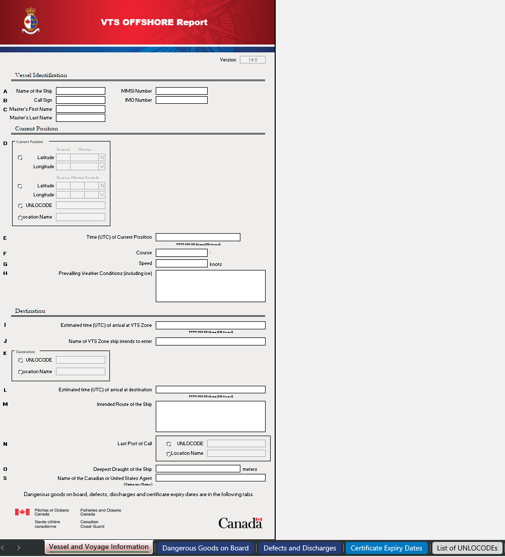
Vessel and Voyage Information

Prior to entering vessel information, it is important to verify the version of the form, located at the top of the report.
Users should ensure that the latest version of the form is downloaded prior to completing the report. This information can be accessed at: Western Canada (VTS Offshore) - Advance Reporting Requirements
Note: In this example, the latest version of the report is 1.4.4. It is important to note that any report version 1.4.X will be accepted. However, if the latest version is 1.5.0 or higher, Prince Rupert MCTS will no longer be able to accept any report version 1.4.X or lower.
Vessels may download the latest copy of the report from the above link, or obtain it from their agents.
After verifying the Version, the first tab of the report contains vessel and voyage information, which is divided into 3 sections:
-Vessel
Identification,
-Current
Position, and
-Destination.
Vessel Identification

This section provides fields to capture the Ship Name, Call Sign, and Master’s first and last name (A-C). Fields for MMSI and IMO numbers are also included.
Note: The form may not allow direct copy and paste of information into the fields; however, information can be copied and pasted into the Excel formula bar.
Current Position
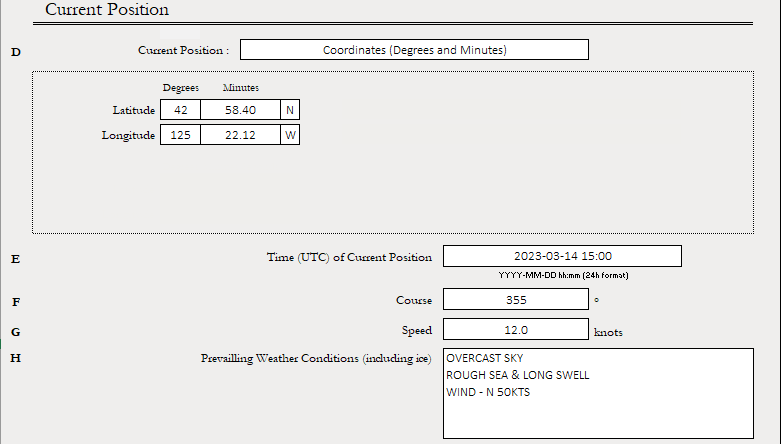
Current Position (D) – This section allows vessels to choose one (1) of four (4) position options:
1)Latitude/Longitude Position using Degrees and decimal
minutes,
2)Latitude/Longitude Position using Degrees, Minutes,
Seconds; or
3)UNLOCODE
4)Location Name
UNLOCODE is a five-character code system used to identify all named geographic places related to international trade. UNLOCODEs are used by most major shipping companies and the manufacturing industry around the world.
Note: When completing this form, the use of UNLOCODEs, where applicable, is preferred to ensure accuracy with MCTS’ vessel voyage management system.
More information about UNLOCODEs can be found here:
https://unece.org/trade/cefact/unlocode-code-list-country-and-territoryTime of the Current Position (E) must be entered in the format as shown.
YYYY-MM-DD hh:mm (24 hour format)
Course, Speed, and Prevailing Weather Conditions, including ice, are to be entered into fields F-H.
Destination

The vessel’s Estimated time of arrival at the Western Canada VTS Zone (I) must be entered in the format shown:
YYYY-MM-DD hh:mm (24 hour format)
The vessel must also provide the Name of VTS Zone that the ship intends to enter (J). This can be done by clicking on the field and selecting from the drop-down menu between the following options:
-Prince Rupert North
-Prince Rupert South
Destination (K) should be the vessel’s First Port of Call in Canadian Waters. Users may choose one (1) of the options for destination:
1)UNLOCODE
2)Location Name
Note: A List of UNLOCODEs, located on tab 5 of the report, also includes a quick reference to Canadian and US locations.
Estimated time of arrival at Destination (L) should be provided in the format as shown:
YYYY-MM-DD hh:mm (24 hour format)
Intended Route of the Ship (M) is a free text field.
Last Port of Call (N) can be entered as a UNLOCODE or a Location Name.
Note: UNLOCODEs will be the preferred method for providing Last Port of Call, however the Location Name can be used if required.
The Deepest Draught of the Ship (O) is to be provided in meters.
The Name of the Canadian or United States Agent (T) should be the company name (not a contact/ individual person’s name).
Additional report information is found in the remaining tabs.
Dangerous Goods on Board
This tab gathers information pertaining to Dangerous Goods Carried on Board, in accordance with item P in RAMN, section 3.8.1.

All three (3) sections of Item P in the VTS Offshore Report must be completed.
At the top of the page, a vessel shall first indicate if dangerous goods are carried by selecting Yes or No to the question “Are there any dangerous goods on the vessel?”
If No is selected, the table will remain greyed out and no entry is required.
If Yes is selected, vessels shall list the type and amount of any dangerous good on board or carried on a vessel/barge being towed or pushed. If carrying dangerous goods, the IMO Class field must also be completed using the drop-down menu. Any additional information can be entered in the free-text Remarks field.
Item P (i) asks a vessel to provide “the type and amount of any oil that is carried in bulk in the ship’s hold”. If the question does not apply, enter Nil or N/A.
Item P (ii) asks a vessel to provide “the type and amount of any oil to be unloaded from or loaded into the ship’s hold at the port or the marine installation”. If the question does not apply, enter Nil or N/A.
Defects and Discharges

Defects and Discharges (R,S) – information shall be provided as per RAMN:
“any defect in the ship's hull, main propulsion systems or steering systems, radars, compasses, radio equipment, anchors or cables;”
”any discharge, or threat of discharge, of a pollutant from the ship into the water, and any damage to the ship that may result in the discharge of a pollutant from the ship into the water”
Note: Please ensure that both Defects (R) and Discharges (S) are completed on this tab.
If Defects are to be reported, check yes and include them in the report by using the “Select a Defect” drop-down menu with remarks.
Discharges must be indicated by selecting “Yes” and including any additional information.
If there are no defects or discharges to report, the vessel must indicate “No” for each of these options.
Certificate Expiry Dates

Vessel Certification Expiry Dates (U)
All applicable certificate expiry information shall be included based on the type of vessel.
If the vessel provides an incorrect or out of date expiry for a certificate, the form will indicate “Expired” to the right of the date.
MCTS may request a copy of certificates on behalf of Transport Canada when required.
List of UNLOCODEs

The vessel may refer to UNLOCODE tabs for information related to destinations or locations in Canadian waters or in the United States. Some common United States last port locations have also been included.
Using the UNLOCODE may reduce misspelled location names, using the wrong location with a similar name, or using a location of the same name but in a different province or territory.
More UNLOCODEs can be found online at:
https://unece.org/trade/cefact/unlocode-code-list-country-and-territory
Report a problem on this page
- Date modified: